Mapping glacier melt signals with satellite radar and scalable cloud computing
My masters degree was supported by a NASA Crysphere program grant to study melt patterns on glaciers across the Hindu-Kush Himalaya (HKH) region. I worked with Professors Nick Steiner and Kyle McDonald to assemble Sentinel-1 time series data across the entire HKH region and develop a retrieval algorithm to map the timing and duration of snow melt on glacier surfaces across the region.
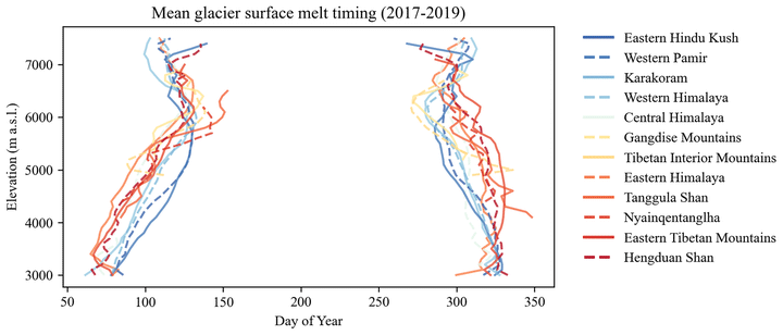
We joined a team of scientists that National Geographic assembled to install the world’s highest elevation meteorological stations on Mount Everest and, as early users of the data collected on Mount Everest, we were able to show that glacier melt signals extend well above elevations where the air temperature is freezing all year round.
This work is important because generations of glacier melt models are driven by assumptions that glacier melting occurs at elevations where seasonal air temperatures exceed 0ºC. Our work helps to show that, across the HKH, this assumption doesn’t hold and the relatively straightforward retrieval methods we developed to map glacier surface melt timing could serve as a new way to calibrate snow and glacier melt models for better understanding of a changing hydrologic regime under a rapidly changing climate.